Building Safely in Fire-Prone Areas: Understanding Bushfire Assessment Reports
Australia’s bushfire seasons are becoming longer and more unpredictable, making fire safety a key consideration for anyone planning to build or renovate near bushland. Whether you are constructing a new home, extending an existing property, or subdividing land, a bushfire assessment ensures your project meets safety standards while protecting people, property, and the environment. Understanding when these reports are needed, what they involve, and how they can shape your design will help you plan effectively and avoid costly delays.
When a Bushfire Assessment Is Needed
Any development located on land designated as bushfire-prone must undergo an assessment before approval. The NSW Rural Fire Service (RFS) provides mapping that identifies these areas, and local councils use this information during planning.
A report is usually required for:
- New residential builds or dual occupancies
- Home extensions that increase the footprint or change room use
- Secondary dwellings, studios, or outbuildings near vegetation
- Subdivisions where bushfire protection measures must be planned from the start
- Schools, child care centres, and other special-use buildings that require stricter fire protection standards
Even small projects can fall within bushfire-prone zones, so checking early can prevent unexpected hurdles later. For example, carports, decks, or garages added near bushland can still influence your risk level and may trigger assessment requirements.
See also: Making a Difference in Our Community with Recycling
What a Bushfire Assessment Report Covers
A professional bushfire assessment report Newcastle focuses on understanding your site’s environment and identifying how bushfire risk can be reduced through innovative design and construction. The report includes:
1. Site and Vegetation Analysis
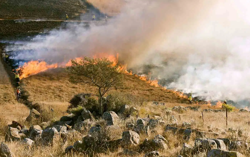
The consultant will examine vegetation types within 100 metres of the building site and classify them in accordance with Australian Standard AS 3959. The slope of the land beneath and around this vegetation is also assessed, since fires travel faster uphill. Together, vegetation type, slope, and distance determine your Bushfire Attack Level (BAL).
2. Bushfire Attack Level (BAL) Rating
The BAL indicates the potential intensity of a fire’s impact on your site. Ratings range from BAL-Low to Flame Zone (FZ), with each level defining the construction standards required for safety. The higher the BAL, the more stringent the building requirements.
3. Asset Protection Zones (APZ)
An APZ is a managed area around a structure that separates the building from bushland. It may involve clearing, landscaping, or maintenance strategies that reduce fuel loads and improve safety for residents and firefighters.
4. Construction Recommendations
The report specifies building materials and design features suitable for your BAL rating. These may include ember-proof mesh, sealed eaves, toughened glass windows, and non-combustible cladding. Adjustments such as shifting the building slightly away from vegetation or changing the orientation can often lower the BAL and reduce costs.
5. Access and Water Supply
Safe driveway design, turning space for fire trucks, and reliable water sources are also assessed. Rural and fringe properties may require dedicated water storage with firefighting fittings, whereas urban areas typically rely on hydrant networks.
Planning and Approval Process
Two main approval pathways apply for developments on bushfire-prone land:
Complying Development Certificate (CDC)
This faster route is available only when the property’s BAL is below 40 and the property is outside the Flame Zone. The property must have a compliant APZ within its boundaries.
Development Application (DA)
This option is used for higher-risk properties or complex designs. Councils may refer these applications to the NSW RFS for review, ensuring they align with the Planning for Bush Fire Protection 2019 (PBP 2019) guidelines and AS 3959 standards.
Starting your assessment early gives you flexibility. If the initial design results in a higher BAL, minor layout changes can often reduce the rating enough to qualify for faster approval under CDC.
Timelines, Costs, and Preparation
A typical bushfire assessment can take one to three weeks, depending on the site and complexity. To prepare, gather:
- A recent site survey showing boundaries, contours, and vegetation
- Architectural plans and elevations
- Photos of the surrounding bushland
- Planning certificates and property title information
For most residential projects, costs range between $900 and $1,800. Larger or more complex developments may cost more. Working with a Bushfire Planning and Design (BPAD) accredited consultant ensures accuracy and compliance with current regulations.
Reducing Risk Through Smart Design
Designing for bushfire resilience is not just about compliance; it’s about long-term safety. Careful siting, low-fuel landscaping, and fire-resistant materials all help reduce risk. Simple measures, such as selecting metal screens, choosing tiled roofs with ember guards, and keeping gardens well-maintained, can make a significant difference.
A professional bushfire assessment report for Newcastle, provides a clear pathway for achieving these outcomes. By combining expert analysis with practical design strategies, you can balance aesthetic goals with essential safety standards.
Conclusion
Building in a bushfire-prone area requires foresight, but it doesn’t have to be complicated. A well-prepared bushfire assessment ensures your design complies with safety standards while maintaining comfort and style. By engaging a qualified consultant early and following their recommendations, you can create a home that blends with the landscape and stands firm in challenging conditions. Planning smart today means peace of mind for years to come.